پرونده:WI 1st Congressional District.png
تفکیکپذیری بالاتری در دسترس نیست.
WI_1st_Congressional_District.png (۶۳۶ × ۳۸۱ پیکسل، اندازهٔ پرونده: ۶۲ کیلوبایت، نوع MIME پرونده: image/png)
این پرونده در ویکیانبار موجود است. محتویات صفحهٔ توصیف آن در زیر نمایش داده میشود. |
| توضیح |
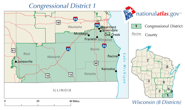
English: Map of Wisconsin's 1st congressional district. Downloaded from http://nationalatlas.gov/printable/images/preview/congdist/wi01_109.gif and converted to PNG. |
|||
| منبع | [http://nationalatlas.gov U.S. National Atlas | |||
| پدیدآور | USGS | |||
| اجازهنامه (استفادهٔ مجدد از این پرونده) |
|
سیاهه بارگذاری اصلی
صفحهٔ اصلی توضیحات اینجابود. همهٔ نامهای کاربر زیر به en.wikipedia اشاره دارند.
- 2007-02-12 09:27 Acntx 636×381× (63962 bytes)
تاریخچهٔ پرونده
روی تاریخ/زمانها کلیک کنید تا نسخهٔ مربوط به آن هنگام را ببینید.
| تاریخ/زمان | بندانگشتی | ابعاد | کاربر | توضیح | |
|---|---|---|---|---|---|
| کنونی | ۱۲ ژانویهٔ ۲۰۱۲، ساعت ۲۰:۵۴ | | ۶۳۶ در ۳۸۱ (۶۲ کیلوبایت) | MGA73bot2 | {{BotMoveToCommons|en.wikipedia|year={{subst:CURRENTYEAR}}|month={{subst:CURRENTMONTHNAME}}|day={{subst:CURRENTDAY}}}} {{Information |Description={{en|Map of Wisconsin's 1st congressional district. Downloaded from http://nationalatlas.gov/printable/ima |
کاربرد پرونده
صفحهٔ زیر از این تصویر استفاده میکند:
کاربرد سراسری پرونده
ویکیهای دیگر زیر از این پرونده استفاده میکنند:
- کاربرد در en.wikipedia.org
- Wisconsin's 1st congressional district
- 2006 United States House of Representatives elections in Wisconsin
- 2008 United States House of Representatives elections in Wisconsin
- 2010 United States House of Representatives elections in Wisconsin
- User:Arms & Hearts/United States House of Representatives elections in Wisconsin, 2010
- کاربرد در ja.wikipedia.org