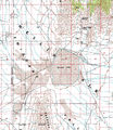
پرونده:Wfm usgs groom map.png

اندازهٔ این پیشنمایش: ۵۲۱ × ۶۰۰ پیکسل. کیفیتهای دیگر: ۲۰۸ × ۲۴۰ پیکسل | ۴۱۷ × ۴۸۰ پیکسل | ۶۶۷ × ۷۶۸ پیکسل | ۸۸۹ × ۱٬۰۲۴ پیکسل | ۱٬۷۱۶ × ۱٬۹۷۶ پیکسل.
پروندهٔ اصلی (۱٬۷۱۶ × ۱٬۹۷۶ پیکسل، اندازهٔ پرونده: ۴٫۹۱ مگابایت، نوع MIME پرونده: image/png)
تاریخچهٔ پرونده
روی تاریخ/زمانها کلیک کنید تا نسخهٔ مربوط به آن هنگام را ببینید.
| تاریخ/زمان | بندانگشتی | ابعاد | کاربر | توضیح | |
|---|---|---|---|---|---|
| کنونی | ۲ آوریل ۲۰۰۶، ساعت ۱۷:۱۶ |  | ۱٬۷۱۶ در ۱٬۹۷۶ (۴٫۹۱ مگابایت) | Finlay McWalter | {{en|Montaged segments of USGS geodetic survey map of southern Nevada, USA, showing Groom Dry Lake and surrounding area. Note that the secret Area 51 base, which satellite photographs confirm is located on the west and south shores of th lake, and its ru |
کاربرد پرونده
صفحهٔ زیر از این تصویر استفاده میکند:
کاربرد سراسری پرونده
ویکیهای دیگر زیر از این پرونده استفاده میکنند:
- کاربرد در ceb.wikipedia.org
- کاربرد در en.wikipedia.org
- کاربرد در www.wikidata.org
