الگو:Infobox Nepal municipality/توضیحات
| این زیرصفحهٔ مستندات الگو:Infobox Nepal municipality است. این شامل اطلاعات استفاده، الگوها، پیوندهای بین زبانی و سایر اطلاعات است که در اصل الگو صفحه قرار نمیگیرد. |
Usage
ویرایش{{Infobox Nepal municipality
| name = <!--Do not add the word "Municipality" -->
| nickname =
| native_name =
| native_name_lang =
| motto =
<!-- image, map-->
| image_skyline =
| imagesize =
| image_alt =
| image_caption =
| map =
| mapsize =
| map_alt =
| map_caption =
| map1 =
| mapsize1 =
| map_alt1 =
| map_caption1 =
<!--pushpin, coord, geo-->
| pushpin_province = <!--for a map of province (Nepal map automatically show)-->
| pushpin_mapsize =
| pushpin_map_caption =
| pushpin_label_position =
| pushpin_relief =
| coordinates =
| coordinates_footnotes =
| province =
| district =
| ward =
<!--established, headquarters-->
| established =
| incorporated_vdc =
| incorporated_date =
| hq, headquarters or seat =
<!--government-->
| government_footnotes =
| mayor =
| mayor_party =
| deputy_mayor =
| deputy_mayor_party =
| parliamentary_constituency =
| mp_name = <!--mp=Member of parliament-->
| mp_party =
| provincial_constituency =
| mla_name = <!--mla=Member of legislative assembly-->
| mla_party =
<!--area-->
| area_magnitude =
| area_footnotes =
| area_total_km2 =
| area_note =
| area_rank =
<!--elevation-->
| elevation_footnotes =
| elevation_m =
| elevation_min_m =
| elevation_max_m =
<!--population-->
| population_footnotes =
| population =
| population_as_of =
| population_density_km2 =
| population_note =
| population_rank =
| households =
<!--others-->
| ethnicity = <!-- ethnic group-->
| female_percent =
| male_per_100_female =
| income =
| poverty =
| literacy =
| life_expectancy =
| languages =
| highways =
| postal_code =
| area_code =
| website =
| footnotes =
}}
Example
ویرایشTriyuga
त्रियुगा नगरपालिका | |
|---|---|
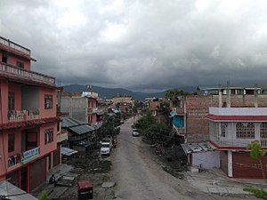
 View of a street in Purano (old) Gaighat, ward no. 11 | |
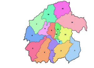
 Ward divisions of Triyuga | |
| مختصات: ۲۶°۴۷′۳۱″ شمالی ۸۶°۴۱′۵۶″ شرقی / ۲۶٫۷۹۱۹۴°شمالی ۸۶٫۶۹۸۸۹°شرقی | |
| کشور | نپال |
| استان | استان شماره ۱ |
| بخش | بخش یودایاپور |
| No. of wards | 16 |
| تاسیس | 26 March 1997 |
| Incorporated (VDC) | Gaighat, Deuri, Bhumrasuwa, Jogidaha, Saune, Khanbu and Jalpachilaune |
| Incorporated (date) | 1997 & 2017 |
| مرکز | Gaighat |
| حکومت | |
| • نوع | Mayor–council |
| • نهاد | Triyuga Municipality |
| • شهردار | Advocate Mr. Baldev Chaudhary (NCP) |
| • معاوم شهردار | Mrs. Devi Chaudhary (کنگره نپالی) |
| • نماینده مجلس و Constituency | Mrs. Devi Chaudhary (کنگره نپالی) |
| • MLA & Constituency | Udayapur 1(B) Himal Karki (کنگره نپالی) |
| مساحت | |
| • کل | ۵۴۷٫۴۳ کیلومتر مربع (۲۱۱٫۳۶ مایل مربع) |
| • رتبه | 1st in province 3rd in Nepal |
| جمعیت (2011) | |
| • کل | ۸۷٬۵۵۷ |
| • رتبه | 5th in province 26th in Nepal |
| • Households | ۱۹٬۴۸۴ |
| جمعیتشناسی | |
| • Ethnic Groups | Chhetri, Tharu, Rai, Magar |
| منطقهٔ زمانی | یوتیسی +۵:۴۵ (NPT) |
| Postal Codes | 56300 |
| Telephone Code | 035 |
| Main Language(s) | زبان نپالی, Tharu, Sunuwar/Kiranti, زبان مایتهیلی, Magar, Gurung |
| وبگاه | www.triyugamun.gov.np |
{{Infobox Nepal municipality
| name                          = Triyuga
| nickname                      =
| native_name                   = त्रियुगा नगरपालिका
| native_name_lang              =
| motto                         =
<!-- image, map-->
| image_skyline                 = Purano Gaighat-11.jpg
| imagesize                     = 300
| image_alt                     =
| image_caption                 = View of a street in Purano (old) Gaighat, ward no. 11
| map                           =  Triyuga municipality divisions.png
| mapsize                       = 300
| map_alt                       =
| map_caption                   = Ward divisions of Triyuga
| map1                          =
| mapsize1                      =
| map_alt1                      =
| map_caption1                  =
<!--pushpin, coord, geo-->
| pushpin_province              = Nepal Province1
| pushpin_mapsize               = 300
| pushpin_map_caption           = Location in Province No. 1
| pushpin_label_position        =
| pushpin_relief                =
| coordinates                   = {{coord|26|47|31|N|86|41|56|E|region:NP-BR|display=inline,title}}
| coordinates_footnotes         =
| province                      = [[استان شماره ۱]]
| district                      = [[بخش یودایاپور]]
| ward                          = 16
<!--established, headquarters-->
| established                   = 26 March 1997
| incorporated_vdc              = [[Gaighat, Nepal|Gaighat]], Deuri, Bhumrasuwa, [[Jogidaha]], [[Saune]], [[Khanbu]] and [[Jalpachilaune]]
| incorporated_date             = 1997 & 2017
| hq      = [[Gaighat, Nepal|Gaighat]]
<!--government-->
| government_footnotes          =
| mayor                         = Advocate Mr. Baldev Chaudhary
| mayor_party                   = [[Nepal Communist Party|NCP]]
| deputy_mayor                  = Mrs. Devi Chaudhary
| deputy_mayor_party            = [[کنگره نپالی]]
| parliamentary_constituency    = [[Pratinidhi Sabha|Udayapur 1]]
| mp_name                       = [[Narayan Khadka|Dr. Narayan Khadka]]
| mp_party                      = [[کنگره نپالی]]
| provincial_constituency       = [[Provincial Assembly of Province No. 1|Udayapur 1(B)]]
| mla_name                      = Himal Karki
| mla_party                     = [[کنگره نپالی]]
<!--area-->
| area_magnitude                =
| area_footnotes                =
| area_total_km2                = 547.43
| area_note                     =
| area_rank                     =1st in province<br/>3rd in Nepal
<!--elevation-->
| elevation_footnotes           =
| elevation_m                   =
| elevation_min_m               =
| elevation_max_m               =
<!--population-->
| population_footnotes          =
| population                    = 87,557
| population_as_of              = 2011
| population_density_km2        =
| population_note               =
| population_rank               = 5th in province<br/>26th in Nepal
| households                    = 19484
<!--others-->
| ethnicity                     = [[Chhetri]], [[Tharu people|Tharu]], [[Rai people|Rai]], [[Magar people|Magar]]
| female_percent                =
| male_per_100_female           =
| income                        =
| poverty                       =
| literacy                      =
| life_expectancy               =
| languages                     = [[زبان نپالی]], [[Tharu language|Tharu]], [[Sunuwar language|Sunuwar]]/[[Kiranti language|Kiranti]], [[زبان مایتهیلی]], [[Magar language|Magar]], [[Gurung language|Gurung]]
| highways                      =
| postal_code                   =56300
| area_code                     =035
| website                       = [http://www.triyugamun.gov.np www.triyugamun.gov.np]
| footnotes                     =
}}
Microformat
ویرایشThe HTML mark up produced by this template includes an hCard microformat, which makes the place-name and location تجزیهکننده by computers, either acting automatically to catalogue article across Wikipedia, or via a browser tool operated by a person, to (for example) add the subject to an address book. For more information about the use of microformats on Wikipedia, please see the microformat project.
If the place or venue has an "established", "founded", "opened" or similar date, specific to the day, use {{Start date}} (unless the date is before 1583 CE); if it has a URL, use {{URL}}.
hCard از کلاسهای HTML زیر استفاده میکند:
- adr
- category
- country-name
- extended-address
- fn
- label
- locality
- nickname
- note
- org
- street-address
- url
- vcard
خواهشمند است این کلاسها را تغییرنام ندهید یا حذف نکنید. عناصر تودرتویی که از آنها استفاده میکنند را نیز به حالت جمعشده درنیاورید.

