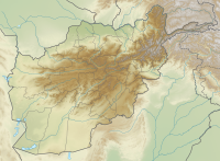
الگو:Location map Afghanistan/توضیحات
| این زیرصفحهٔ مستندات الگو:Location map Afghanistan است. این شامل اطلاعات استفاده، الگوها، پیوندهای بین زبانی و سایر اطلاعات است که در اصل الگو صفحه قرار نمیگیرد. |

Template:Location map Afghanistan is a location map definition used to overlay markers and labels on an equirectangular projection map of افغانستان. The markers are placed by عرض جغرافیایی and طول جغرافیایی coordinates on the default map or a similar map image.
Usage
ویرایشThese definitions are used by the following templates when invoked with parameter "Afghanistan":
{{Location map|Afghanistan |...}}{{Location map many|Afghanistan |...}}{{Location map+|Afghanistan |...}}{{Location map~|Afghanistan |...}}
Map definition
ویرایش- name = افغانستان
- Name used in the default map caption
- image = Afghanistan location map.svg
- The default map image, without "Image:" or "File:"
- top = 38.8
- عرض جغرافیایی at top edge of map, in decimal degrees
- bottom = 29
- Latitude at bottom edge of map, in decimal degrees
- left = 60
- طول جغرافیایی at left edge of map, in decimal degrees
- right = 75.3
- Longitude at right edge of map, in decimal degrees
Examples using location map templates
ویرایشLocation map, using default map (image)
ویرایش{{Location map | Afghanistan
| width = 200
| lat_deg = 34.53
| lon_deg = 69.16
| label = Kabul
}}
Location map many, using relief map (image1)
ویرایش{{Location map many | Afghanistan
| relief = yes
| width = 200
| caption = Two locations in Afghanistan
| lat1_deg = 34.53
| lon1_deg = 69.16
| label1 = Kabul
| lat2_deg = 31.62
| lon2_deg = 65.72
| label2 = Kandahar
}}
Location map+, using AlternativeMap
ویرایش
{{Location map+ | Afghanistan
| AlternativeMap = Afghanistan physical map.svg
| width   = 200
| caption = Two locations in Afghanistan
| places  =
  {{Location map~ | Afghanistan
  | lat_deg = 34.53
  | lon_deg = 69.16
  | label   = Kabul
  }}
  {{Location map~ | Afghanistan
  | lat_deg = 31.62
  | lon_deg = 65.72
  | label   = Kandahar
  }}
}}
See also
ویرایش- Template:Location map Afghanistan2, a different map image with different edge coordinates
- Location map templates
- Template:Location map, to display one mark and label using latitude and longitude
- Template:Location map many, to display up to nine marks and labels
- Template:Location map+, to display an unlimited number of marks and labels
- Infobox templates incorporating (passing values to) the Location map template
- Template:Infobox airport — alternative map support: AlternativeMap (via pushpin_image)
- Template:Infobox archaeological site
- Template:Infobox artwork
- الگو:جعبه اطلاعات ساختمان
- Template:Infobox casino
- الگو:جعبه سد
- Template:Infobox glacier (via Infobox mountain/map)
- Template:Infobox historic area
- Template:Infobox historic site
- Template:Infobox hot spring (via Infobox map) — alternative map support: relief
- Template:Infobox hotel
- Template:Infobox map (used by other infoboxes) — alternative map support: relief
- Template:Infobox military structure
- Template:Infobox monastery
- الگو:دادان کوه (via Infobox mountain/map)
- Template:Infobox mountain/map (used by mountain, glacier)
- Template:Infobox park (via Infobox map) — alternative map support: relief
- الگو:جعبه اطلاعات منطقه حفاظتشده (via Infobox map) — alternative map support: relief
- الگو:Infobox settlement — alternative map support: AlternativeMap (via pushpin_image)
- Template:Infobox valley (via Infobox map)
- الگو:جعبه اطلاعات آبشار (via Infobox map) — alternative map support: relief
- Template:Infobox World Heritage Site — alternative map support: relief

